Dataset includes various regional-scale spatial data layers in geojson format.
As of 1969, the scientific community had no general information on the natural history of Namoluk Atoll in the Eastern Caroline Islands of Micronesia. The only significant published source for the atoll was an ethnographic and linguistic account provided by the German physician.
Climate change is real and Asia is already experiencing its adverse impacts. Projections from the Intergovernmental Panel on Climate Change (IPCC) suggest that such impacts will become even more intense in the future. While the contribution of developing countries in Asia to global greenhouse gas (GHG) emissions is increasing rapidly, per capita emissions are still low and developmental challenges remain significant.
The USGS Earthquake Hazards Program of the U.S. Geological Survey (USGS) is part of the National Earthquake Hazards Reduction Program (NEHRP) led by the National Institute of Standards and Technology (NIST).
Reefs at Risk Revisited is a high-resolution update of the original global analysis, Reefs at Risk: A Map-Based Indicator of Threats to the World’s Coral Reefs. Reefs at Risk Revisited uses a global map of coral reefs at 500-m resolution, which is 64 times more detailed than the 4-km resolution map used in the 1998 analysis, and benefits from improvements in many global data sets used to evaluate threats to reefs (most threat data are at 1 km resolution, which is 16 times more detailed than those used in the 1998 analysis).
Data submitted to the UN Ozone Secretariat highlighting the trend of ODS consumption (calculated as Production (if any) + imports - exports) in Palau. Ozone Depleting Substances calculated here are HCFCs and Methal Bromide.
Regional framework to assess the regional monitoring indicators that measure the status of managed conservation areas set aside under the Micronesia Challenge. The tool allows you to see the monitoring progress and learn more about the monitoring data collected across the region.
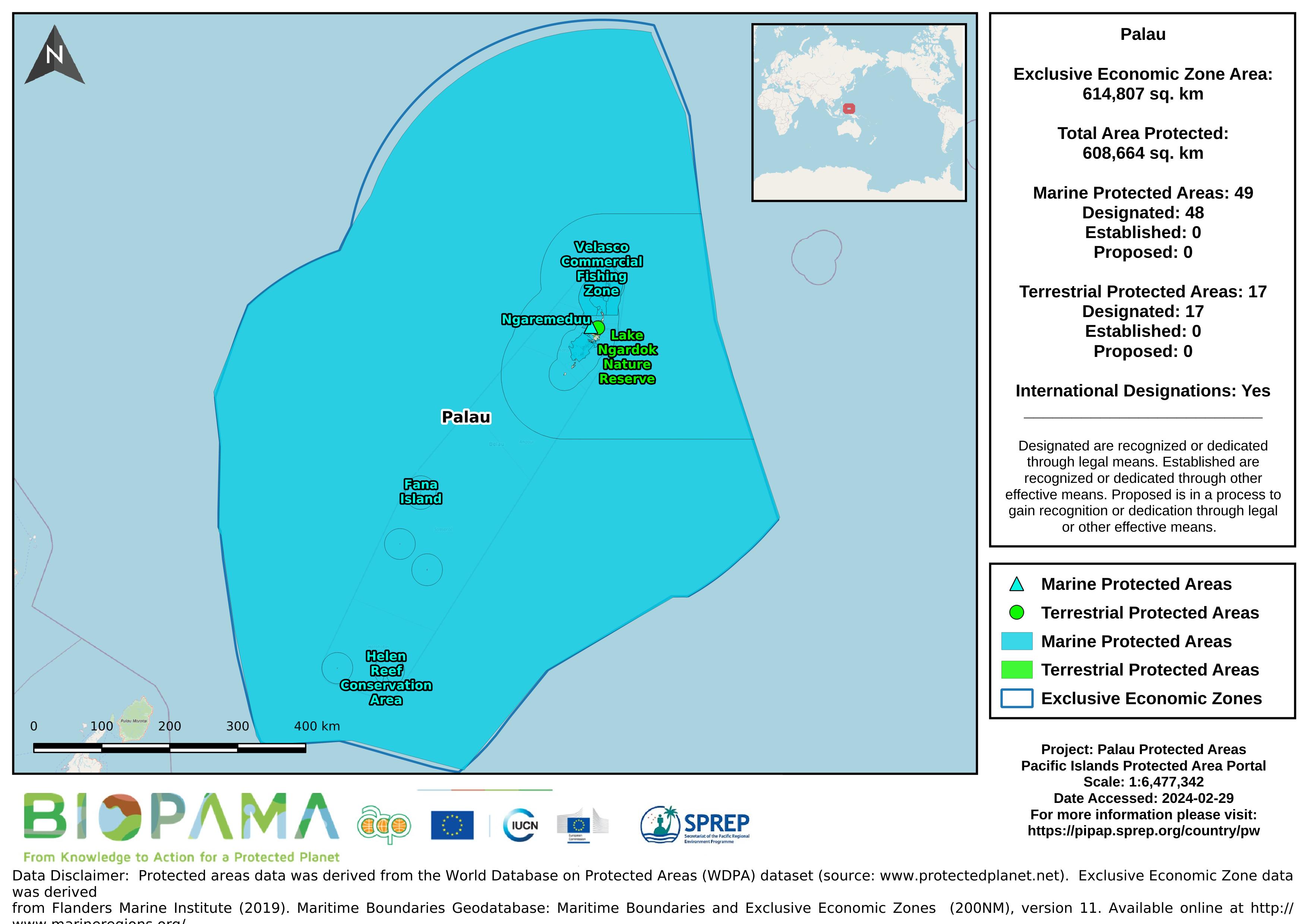
The World Database on Protected Areas (WDPA) is the most comprehensive global database of marine and terrestrial protected areas, updated on a monthly basis, and is one of the key global biodiversity data sets being widely used by scientists, businesses, governments, International secretariats and others to inform planning, policy decisions and management.
This dataset provides direct internet links to Palau's data hosted on the GBIF website/ records.
Dataset that provides a direct internet link to Palau's climate change data portal.
Map of the protected areas for Palau with country-level summary statistics on the amount of area under protection, count for each type of protected area (terrestrial or marine), and the count of their designation.
Map of the protected areas for Palau with country-level summary statistics on the amount of area under protection, count for each type of protected area (terrestrial or marine), and the count of their designation.
Map of the protected areas for Palau Island with country-level summary statistics on the amount of area under protection, count for each type of protected area (terrestrial or marine), and the count of their designation.
Map of the protected areas for Palau Island with country-level summary statistics on the amount of area under protection, count for each type of protected area (terrestrial or marine), and the count of their designation.
the link directly leads to the Republic of Palau's data on the Micronesia Challenge website
Dataset that provides a direct internet link to Palau's climate change data portal.
Pacific islands region exclusive economic zones (EEZs)
**draft only**
This report presents a set of indicators, referred to as the 'core' set. for reporting on the state of the environment across Commonwealth and State and Territory jurisdictions. The core indicators have been developed by the Australian and New Zealand Environment and Conservation Council (ANZECC) through an extensive consultation process involving both government agencies and the general public.
As of 1969, the scientific community had no general information on the natural history of Namoluk Atoll in the Eastern Caroline Islands of Micronesia. The only significant published source for the atoll was an ethnographic and linguistic account provided by the German physician.