Dataset includes various regional-scale spatial data layers in geojson format.
AquaMaps are computer-generated predictions of natural occurrence of marine species, based on the environmental tolerance of a given species with respect to depth, salinity, temperature, primary productivity, and its association with sea ice or coastal areas. These 'environmental envelopes' are matched against an authority file which contains respective information for the Oceans of the World. Independent knowledge such as distribution by FAO areas or bounding boxes are used to avoid mapping species in areas that contain suitable habitat, but are not occupied by the species.
The USGS Earthquake Hazards Program of the U.S. Geological Survey (USGS) is part of the National Earthquake Hazards Reduction Program (NEHRP) led by the National Institute of Standards and Technology (NIST).
Data submitted to the UN Ozone Secretariat highlighting the trend of ODS consumption (calculated as Production (if any) + imports - exports) in Palau. Ozone Depleting Substances calculated here are HCFCs and Methal Bromide.
Location and distribution of MPAs on the east side of Babeldaob. Data obtained from WDPA dataset
Regional framework to assess the regional monitoring indicators that measure the status of managed conservation areas set aside under the Micronesia Challenge. The tool allows you to see the monitoring progress and learn more about the monitoring data collected across the region.
The World Database on Protected Areas (WDPA) is the most comprehensive global database of marine and terrestrial protected areas, updated on a monthly basis, and is one of the key global biodiversity data sets being widely used by scientists, businesses, governments, International secretariats and others to inform planning, policy decisions and management.
This dataset provides direct internet links to Palau's data hosted on the GBIF website/ records.
Dataset that provides a direct internet link to Palau's climate change data portal.
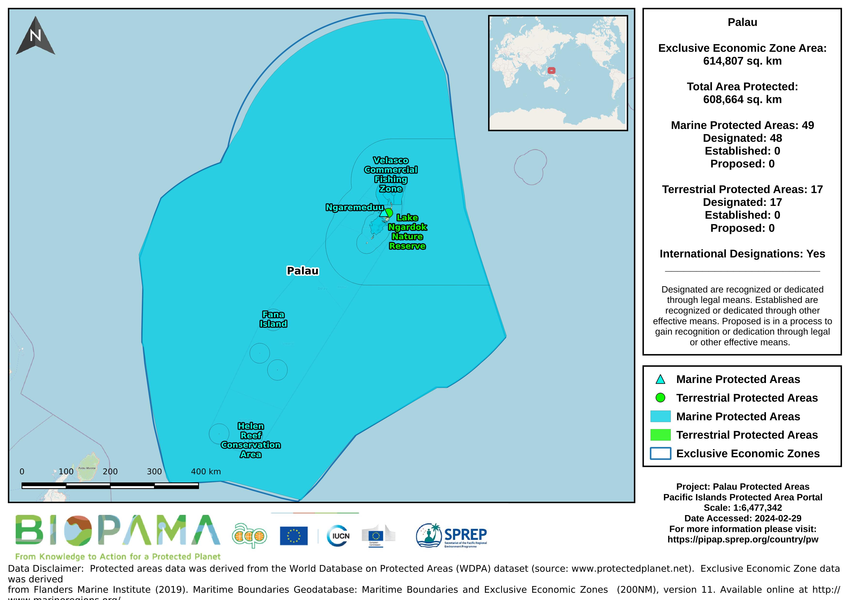
Map of the protected areas for Palau with country-level summary statistics on the amount of area under protection, count for each type of protected area (terrestrial or marine), and the count of their designation.
Map of the protected areas for Palau Island with country-level summary statistics on the amount of area under protection, count for each type of protected area (terrestrial or marine), and the count of their designation.
the link directly leads to the Republic of Palau's data on the Micronesia Challenge website
Dataset that provides a direct internet link to Palau's climate change data portal.
Pacific islands region exclusive economic zones (EEZs)
Rural and urban population 1990 - 2017, FAOSTAT (website: http://www.fao.org/faostat/en/#country/180)
direct link to Palau's data on the GBIF website
CSV file containing the global distribution of hydrothermal vent fields in WGS84 coordinate system.
GeoJSON file for earthquake centers over a magnitude of 4.5 for the Pacific Islands Region for years 2000-2004. Data are derived from the ANSS Comprehensive Earthquake Catalog (ComCat). ComCat contains earthquake source parameters (e.g. hypocenters, magnitudes, phase picks and amplitudes) and other products (e.g. moment tensor solutions, macroseismic information, tectonic summaries, maps) produced by contributing seismic networks.
GeoJSON file for earthquake centers over a magnitude of 4.5 for the Pacific Islands Region for years 2005-2009. Data are derived from the ANSS Comprehensive Earthquake Catalog (ComCat). ComCat contains earthquake source parameters (e.g. hypocenters, magnitudes, phase picks and amplitudes) and other products (e.g. moment tensor solutions, macroseismic information, tectonic summaries, maps) produced by contributing seismic networks.