Shape file polygons-geojson
This dataset contains mapped point locations for protected areas within Palau. This dataset should be viewed in combination with the World Database on Protected Areas polygon locations to get a comprehensive view of all protected areas within Palau.
This dataset contains mapped polygon locations for protected areas within Palau. This dataset should be viewed in combination with the World Database on Protected Areas point locations to get a comprehensive view of all protected areas within Palau.
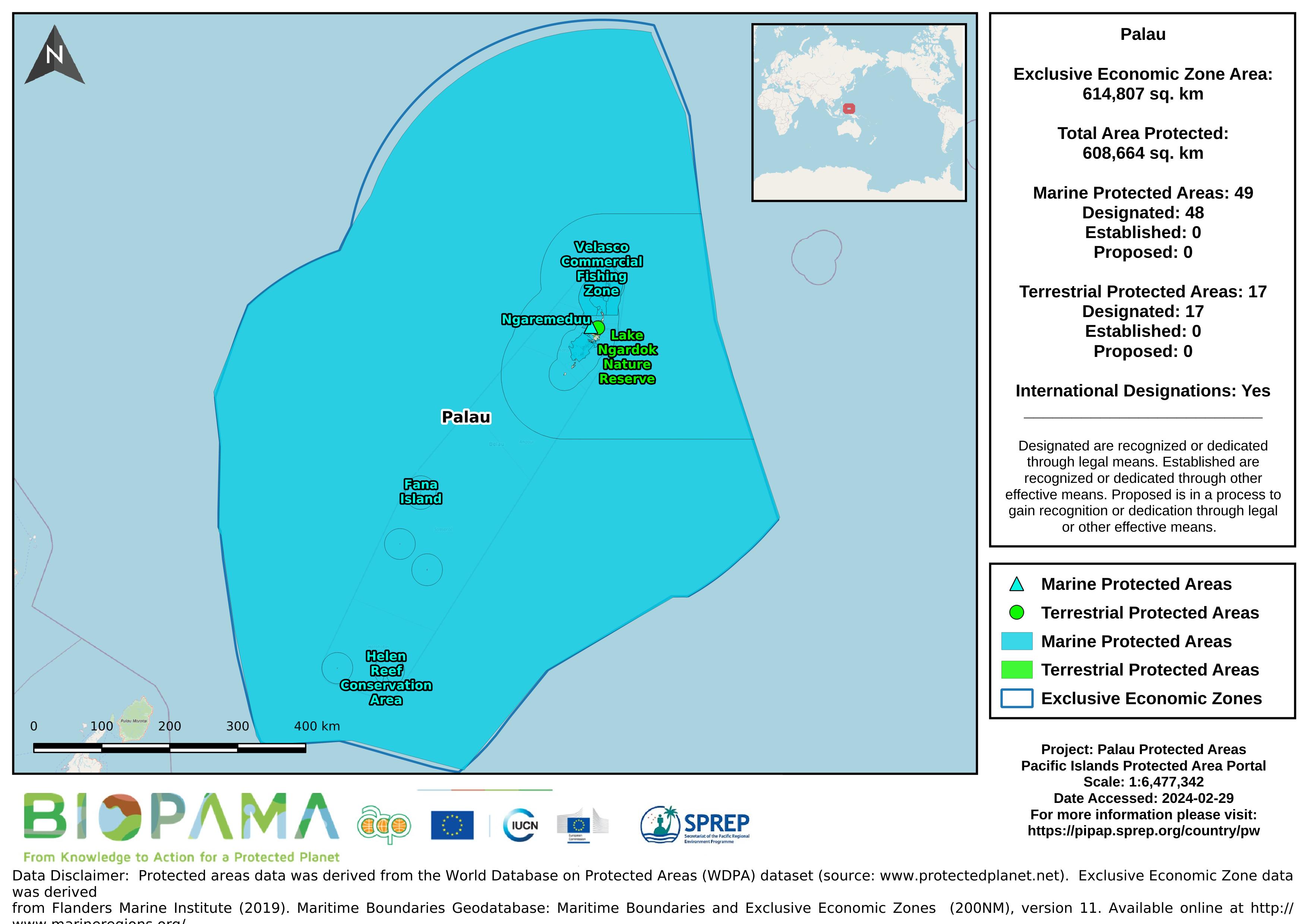
Map of the protected areas for Palau with country-level summary statistics on the amount of area under protection, count for each type of protected area (terrestrial or marine), and the count of their designation.
Map of the protected areas for Palau Island with country-level summary statistics on the amount of area under protection, count for each type of protected area (terrestrial or marine), and the count of their designation.
the link directly leads to the Republic of Palau's data on the Micronesia Challenge website
Dataset that provides a direct internet link to Palau's climate change data portal.
Pacific islands region land area
GIS file (geojson format) displaying protected areas in Palau.
direct link to Palau's data on the GBIF website
Metadata file for the GIS data (raster and shapefiles) for the global threats to coral reefs: acidification, future thermal stress, integrated future threats, and past thermal stress.
Metadata file for the GIS data (raster and shapefiles) for the local threats to coral reefs: coastal development, integrated local, marine pollution, overfishing, and watershed pollution.
Excel file with spreadsheets for each species. Downloaded from TREDS May 2021.
In 2007, a total of 230 species found in Palau were listed on the International Union for Conservation of Nature and Natural Resource (IUCN) Red List as vulnerable to some degree including 53 species listed as near threatened, vulnerable, or endangered 64 species listed as data deficient.
Calculated as Production (if any) + Imports - Exports
A direct internet link to easily access more ODS related data for Tuvalu on the UNEP Ozone Secretariat website
A direct internet link to easily access more ODS related data for Tuvalu on the UNEP Ozone Secretariat website
Koror and Airai have the highest populations in Palau with more development (roads, residential development and
industry). By comparison, Kayangel and Ngarchelong have small populations and very limited pollution. Loss of fish
catch from terrestrial pollution for Hatohobei and Sonsorol, two states with minimal population and negligible development, is assumed to be zero, and they are not included in the estimates.
GeoJson Data Previews - shapefile points